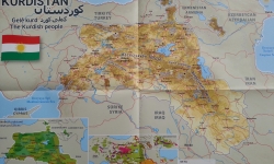
STRASBURG, France, — Eurominority or what is known as the Stateless Nations and Minority Peoples in Europe has just published the new map of Kurdistan as displayed.
Eurominority and the Kurdish Institute of Paris (Institut kurde de Paris) released a new map of Kurdistan with the purpose of acknowledgment of the “Nation of Mount Ararat”, the report said.
Published in Kurdish and English, the map shows the main Kurdish cities, mountains, rivers as well as the lakes that form the historical and grand Kurdistan.
Two additional maps also give a good point of view of the Kurdish provinces distributed Among the Turkish, Syrian, Iranian and Iraqi States.
The poster also presents a simplified map of dialects of the Kurdish language, thus making the work one of the most synthetic maps of historical Kurdistan.
The map involves the provinces of Maraş, Elbistan, Koçgiri, Erzincan, Erzurum, Kars, Igdir, Agrı, Maku, Urmiye, Mahabad, Bicar, Kirmaşan, Ilam, Xaneqin, Kerkuk, Musul, Qamişlo and Afrin.
Eurominority was founded by Mikael Bodlore-Penlaez for the promotion of the Stateless Nations and national minorities of Europe in 1999.
The establishment aims to publish researches and information obtained through an expansive network of correspondents across Europe. The website provides online service in 30 languages.
